LANDFORMS RESULTING FROM FOLDING, FAULTING AND VOLCANIC ACTIVITY
Objectives: By the end of this subtopic learners should be able to:
Describe the internal structure of the earth.
Outline the main causes of instability in the earth's crust.
Describe and explain processes and landforms resulting from instability in the earth's crust.
Point out positive and negative effects of earth movements.
Earth's Structure
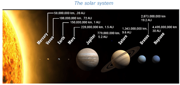
The earth is one of the nine planets that revolve around the sun.
In their order of distance from the sun, the planets are: Mercury, Venus, Earth, Mars, Jupiter, Saturn, Uranus, Neptune and Pluto.
All planets are spherical in shape.
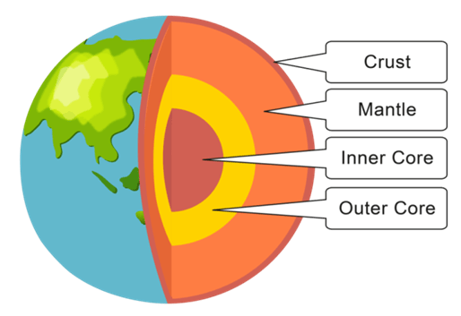
The main zones of the earth's internal structure
The earth has a geoid shape which means that it is almost spherical but slightly flattened at the poles and bulging at the equator.
The earth's interior is made up of three main zones which are crust, mantle and core as shown in the diagram below.
The core is further divided into an inner core and an outer core.
These layers or zones influence the nature of processes and landforms that we see every day in our physical environment.
Earthquakes, volcanoes and mines inform us a lot in the understanding of the internal structure of the earth.
a) Earth's crust
Definition: The earth crust or lithosphere is the outermost zone or layer of the earth's internal structure.
Characteristics
It is made up of solid matter that is in the form of rocks and soil.
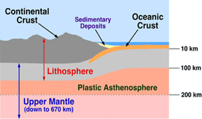
It consists of two layers: continental crust and oceanic crust as shown in the diagram above.
The oceanic crust is between 5 and 10 km in thickness and is made up of heavier rocks such as gabbro and basalt.
The oceanic crust is often referred to as ‘sima' (short for silica and magnesium) because these are the common minerals in basalt and gabbro.
The continental crust on the other hand is thicker (30 to 50km) but made up of slightly less dense felsic rocks such as granite.
The continental crust is often referred to as ‘sial' (short for Silica and aluminium) which are common minerals in rocks such as granite.
Both the continental and oceanic crusts sit on a second layer called the mantle.
Owing to movements in the interior of the earth that shall be discussed later, the crust is broken up into plates
b) Mantle
It is a thick layer below the earth's crust made up of molten rock.
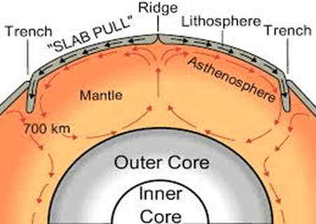
The mantle is about 2900km thick and is made up of olivine rocks such as peridotite.
These rocks are constantly heated by the core and thus set up convection currents that cause movements in the crust (see diagram below).
Between the crust and mantle is a semi-molten or plastic zone, called the Mohorovic discontinuity.
The mantle which is also known as mesosphere is separated from the core by the Gutenberg Discontinuity (named after a German who discovered it).
c) The core
The core is also known as the barysphere.
It comprises of an inner core and an outer core.
The outer core is semi solid while the inner core is solid.
The core is made up of iron (fe) and nickel(ni) rocks.
Chemical reactions happen in the core which release great amounts of heat that cause convection currents in the mantle.
Temperatures in the inner core are extremely high, ranging from 9000 to 13000ËšC.
Causes of instability in the Earth's interior
Convection currents
These are spiral movements of gases and liquid minerals beneath the crust.
They are caused by extreme temperatures which make gas and mineral particles to expand and become highly volatile.
The particles and molecules diffuse towards low temperature zones thereby causing the cooler gas particles to sink and allow circular like motions.
The trend is spread along the circumference of mantle and observed as moving circles.
It is also important to note that the welling up and down of the convection currents is one responsible for movements in the crust.
The nature of convection currents' movements near the crust determine the headward or backward movement of the plate.
If the movement below is towards the right, the plate follows the same pattern.
Where vertical rise of currents hit the crust, it is also made to rise in accordance.
These movements within create instability which causes the plates to drift, cracks or fissures to open, then allow volcanoes to erupt.
Types of rocks
Igneous
The word comes from the Latin word "Ignus" which basically means 'fire rock'.
Igneous rocks within the crust are formed from rising molten magma from the mantle which later cools to crystallize.
The ones formed on the crust's surface are from magma that reaches or flows out as lava.(i.e. magma becomes lava when it flows out to the surface)
Rocks formed by these two processes have different characteristics, as sizes and appearances of grains are determined by rate of cooling.
The rising of magma upward from the mantle is referred to as vulcanicity which is enhanced by cracks or fissures within.
Sudden cooling promotes fine grained rocks due to deep granular contractions.
When magma cools before it reaches the surface it forms plutonic rocks,also classified as intrusive rocks.
The ones reaching the surface are extrusive and volcanic.
Nature of cooling and rock characteristics
Extrusive rocks
When the molten magma reaches the crust's surface as lava, it experiences low temperatures of 40ËšC or even below.
The enormous drop in temperatures from a thousand plus to 40ËšC causes the cooling lava to shatter then solidify and crystallize into small or fine grained particles .
Sometimes lava disintegrates along lines or patterns of weaker mineral composition causing some of the boulders to be angular in shape.
The nature of volcanic eruption also determines the pattern of solidifying lava.
If the lava flows slowly,short steep flows result.
Long thin flows are evidenced from a rapid flow.
When ejected violently into the air, ash and tuffs fall back to the ground.
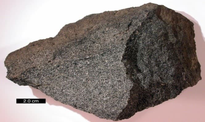
Basalt is the common extrusive rocks among others which are difficult to distinguish due to their fine grained nature.
Intrusive rocks
These are rocks formed within the crust due to failure of magma to reach the surface of the crust.
Some of these newly formed rocks are found beneath or joined to pre-existing rock formations, as in the case of mountain ranges which continue to have batholiths in the making beneath.
The mineral grains of these rocks are large and identifiable to the eye and this makes them distinguishable.
Three main types of rocks found are granite, gabbro and dolerite.
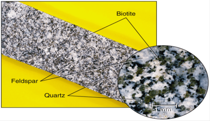
Granite is made up of quartz, mica and feldspars as minerals.
Feldspars are compounds of calcium, sodium, potassium and aluminum which undergo ionic bonding processes.
Quartz, referred to as silica, is a result of oxygen and silicon bonding into a compound.
On a granite rock, the black spots or grains are mica (biotite), the shiny glassy ones quartz and the milky white ones are feldspar.
Other Igneous rocks and minerals
Rock
Minerals
Limestone
Quartz, feldspar, mica
Sandstone
Quartz, feldspar, calcite
Basalt
Dolomite, calcite
Shale
Quartz, feldspar, mica
Beneath the earth's crust, igneous rocks are found in stocks of several appearances.
Batholiths, dykes, laccoliths, lopoliths, sills and volcanic pipes are common intrusive features.
Sedimentary Rocks
The rocks are a result of deposited sediments by water, wind and ice then compressed through time to form a layered structure.
The river processes are to a larger extent responsible for 75 percent of sedimentary rock formations.
Material composed of dead plants and others termed river load are consequently deposited in low lying river sections where they are hardened through compression.
In areas with dense vegetation cover, the wood waste rich in carbon gives rise to coal, chalk and limestone formations which are organic sedimentary rocks.
The weight of seasonally embedded sediments continuously presses the former strata below thereby squeezing the particles together.
The result of such compression is a solidified layer or stratum.
The plane between the layers is called bedding plane.
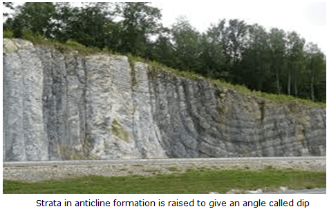
Due to plate movements the strata may tilt and the angle of the titled strata to the horizontal plane is called dip.
Two major classes of sedimentary rock formations are organic and inorganic.
Under inorganic, there are rocks chemically and mechanically composed.
The inorganic sedimentary rocks formed in water are sandstone and mudstone.
Those formed on land are boulder clay, loess and moraines.
Those that are mechanically formed are clay, alluviums and gravels which are deposited by water.
Moraines, boulder clay and gravels are deposited by ice.
Loess is product of wind action.
Chemically composed sedimentary rocks result from elements in different rock materials that react in the presence of water and air to form salts.
Examples of rocks from these chemical reactions are potash, certain lime stones, gypsum, nitrates and rock salt.
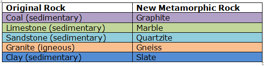
Metamorphic rocks
When rocks are subjected to great heat and pressure, their structure and appearance is altered.
Sedimentary and igneous rocks can be changed into metamorphic rocks when they come into contact with great heat and pressure resulting from volcanic activity.
The intrusive ones continue to be altered through high temperatures below and are later exposed to the crust's surface through weathering and erosion processes.
Plate tectonics
Continental drift theory
This theory came about after observing that continents of the world seemed to fit together if viewed on an atlas.
Alfred Wegener, of German origin, put forward a theory which argued that a supercontinent that he gave a name ‘Pangaea' once existed.
It was surrounded by an ocean he called Panthalassa.
It broke up initially into two, forming two sub-continents Lauarsia and Gondwanaland.
These two sub-continents were separated by an ocean called Teths.
With time these sub-continents broke up to become the continents that we have at present.
Africa remains the core of what was Gondwanaland while Europe is the core of what was Laurasia.
Evidence supporting Continental drift theory
Alfred Wegner had several fundamental points as evidence to his theory.
The jig-saw fit of continents: if several continents are moved together they seem to fit. The imaginary shifting of South America towards the western side of Africa would make the edges fit together.
The similar trend would apply to all continents surrounding Africa, if they were to be moved to the African continent.
Such a fit would create one solid landmass that once existed though certain edges have been eroded away.
Similarities of rocks and minerals: The occurrence of similar rock alignments in different continents also suggests that these continents were at one time together.
Scientific methods of magnetic dating and alignment have been used to show similarities of rocks.
Flora and fauna: similar species of wildlife and plants have implications of having existed in the same geographical location through time.
Paleontology: Similarities of fossils of dinosaurs and reptiles between South America and Africa also indicate towards the fact the continents were once joined.
Similar relief: mountain ranges formed by folding processes seem to continue as we move into the next continent and they are of the same age. Examples are the Falkland Mountains in South America and the Cape Mountains in South Africa.
Theory of plate Tectonics
Continental drift theory had a problem of not explaining the causes of the mechanism that caused movement of continents.
This led to the development of the plate tectonics theory.
Plate tectonics states that the earth is fractured into plates and continents sit on these plates like they are on a conveyor belt.
Convection currents in the interior of the earth cause movement of the plates towards, away or against each other.
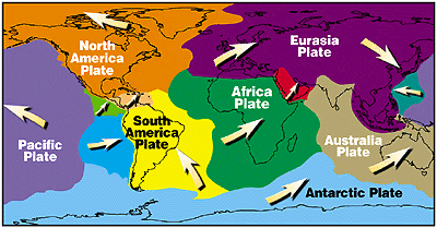
The diagram below shows world's major tectonic plates.
The world's major tectonic plates
Causes of plate movements
The theory of continental drift later gave way to the plate tectonics theory that clearly explained the forces behind the splitting of continents.
The basis of the theory was plate movements and forces behind that movement.
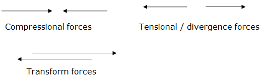
Plate tectonics therefore explains that tensional and compressional forces just beneath the crust are responsible for the tearing, shearing, folding and faulting of plates.
These forces are created by convection currents on the upper part or layer of the mantle referred to as asthenosphere.
The two ways in which the tectonic plates carrying continents move are through convergence and divergence.
Convergence is when plates move towards each other to cause a collision, while divergence is when the plates drift away from each other to cause a fault or a crack.
Two types of forces impacting on these movements are tensional and compressional.
The vertical up and down movements which are the opposite of lateral movements also cause plates to fault.
Landforms produced by tectonic movements
There are three basic forces associated with movement of tectonic plates and these are compression, tension and shear or transform.
These forces are responsible for the production and destruction of landform features in the earth's crust.
On plate boundaries where these forces act, oceanic trenches, mountain building, volcanic activity and earthquakes occur.
The movements of plates are gradual and range from zero to 100mm annually.
Actual movement of plates is difficult to observe by eye because it is very slow.
On plate boundaries where these forces act, oceanic trenches, mountain building, volcanic activity and earthquakes occur.
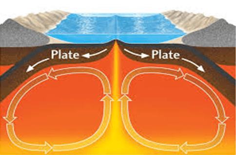
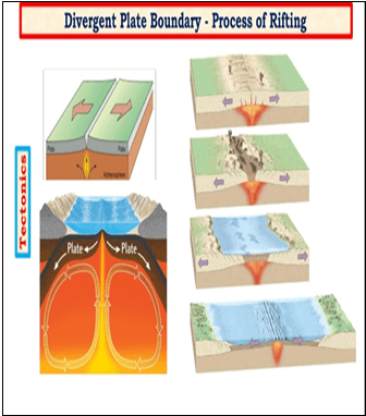
Constructive zones
These are plate boundaries where tensional forces are in action.
Most of the boundaries where tensional forces occur are in oceanic plates where the thickness of the crust tends to be thinner than the continental crust.
Cracks or faults develop faster due to convectional currents that are persistent underneath the earth's crust.
As these forces continue to drag the upper layer of the crust along convections, the boundary of plates splits and causes a fault.
The process is usually accompanied by volcanism.
Molten magma eventually pushes out along fault lines to create lava flows or ash and cinder cones.
The process enables such boundaries to be referred to as constructive zones.
Examples of such constructive boundaries are African and South American plate, and Eurasian and North American plates.
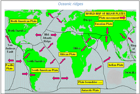
Oceanic ridges are fault lines where magma is issuing out to form mountain ranges under the sea.
If we refer to the map below we see the Mid Atlantic ridge running north-south between Africa and South America.
Divergent boundaries also result in landforms like rift valleys.
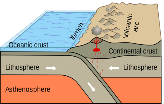
Destructive zones
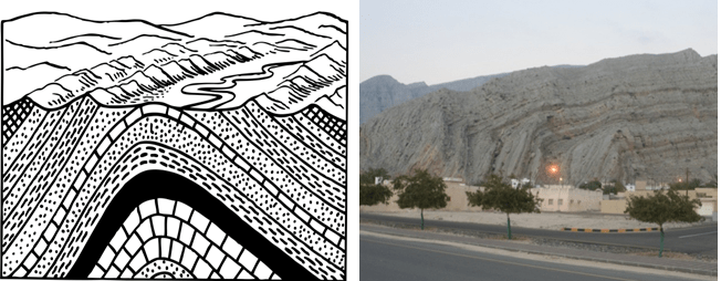
The destructive zones are usually associated with convergence forces which cause tectonic plates to collide.
Outstanding features are produced for example when an oceanic plate collides with a continental plate.
The diagram below shows such a collision that forces the heavier oceanic plate to sink below the lighter continental plate, a process known as plate seduction in geography.
Referring to the map of tectonic boundaries shown before, the South American and NAZCA plates typically show such plate subduction.
When the oceanic plate subsides under the more rigid and lighter continental plate, it disappears into the mantle hence revealing the destructive effects of compressional forces.
The edges of the ocean sea floor are exposed to great heat from the mantle that causes them to melt and disappear.
On the continental plate side/front fold mountains appear and the Andes Mountains in South America and Atlas Mountains in Africa are examples.
Owing to the sinking of the oceanic crust an oceanic trench is formed.
This trench usually creates a "V" shaped zone that is open to receiving denudation materials or sediments which later on fill it up and are then are compressed into fold mountains.
Oceanic trenches are some of the deepest parts of oceans e.g. Mariana Trench in the Pacific Ocean which is the deepest place in the world.
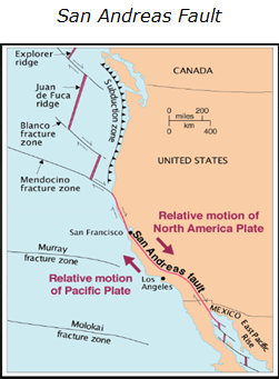
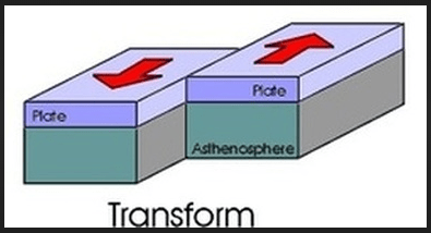
Neutral boundaries
These are boundaries where transform/shear forces are in action.
In this case, two plates are rubbing against each other as they move in opposite directions.
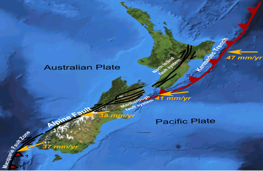
Examples of neutral boundaries include the famous San Andreas Fault transform boundary in California USA.
Folding and Faulting
Folding
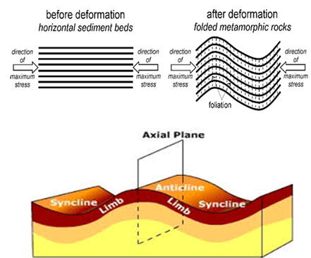
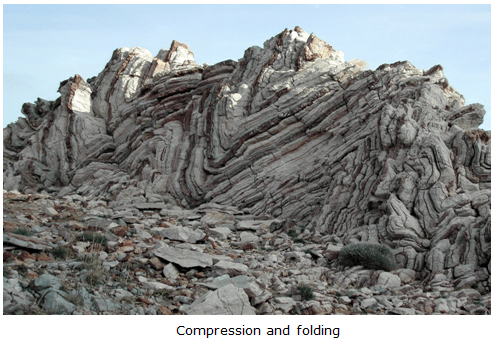
A fold: is usually a bulge upwards or warping of a previously horizontal plane as a result of forces of compression.
The forces of compression simultaneously create two landform features which are anticlines (ups) and synclines (downs).
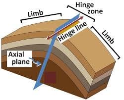
Within the synclines and anticlines, the layers or strata respond to the movements thereby changing their form to mean a fold. (see diagram below)
The structure of the fold is made up of two limbs rising to the apex or fold's top part.
The syncline which is a depression beneath the rise is sometimes referred to as valley.
The anticline is the top part of the bulge usually referred to as ridge.
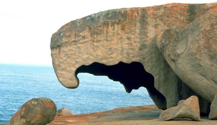
In some cases the apex (top part) of the folds are eroded by agents of denudation, giving rock structures which are vertically standing longitudinal blocks, for example those in the picture above.
The folds are more distinct in sedimentary rock areas where limestone is easily up heaved in its general softness.
Types of folds
There are four main types of folds which are simple fold, asymmetrical fold, over fold and overthrust fold or thrust fault.
Simple fold is the bending outwards of the plate from the horizontal plane to form a hump like feature.
The limbs are concave in nature, and follow a gentle rise.
Asymmetrical fold has the other limb following a convex protrusion while the other maintains a gentle slope to the top.
This happens when there is unequal force on one limb which then tends to override the other.
The angle on the convex slope is closer to being a right angle hence making it steep while the concave slope is closer to an acute angle which makes it gentle.
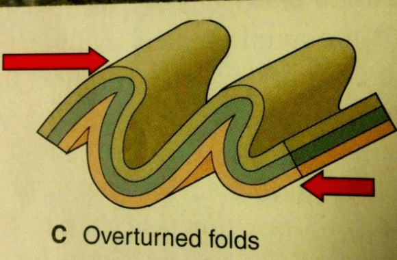
Over fold is when the other limb is bended inwards as the overriding effect of the other limb progresses. It may also be referred to as overturned fold or recumbent fold.
An overthrust fold results when one limb completely overrides the other such that the bended limb reaches or exceeds the point at which it can limit a crack or fault from developing.
This is also called a fault because of the break in rocks.
Examples of fold mountains in Zimbabwe are the Chimanimani in the eastern highlands.
Faulting
A fault is a line of fracture or openness that occurs due to movement in the earth's crust. There are three types of faults created by the forces responsible for plate tectonics namely compression, tension and transverse.
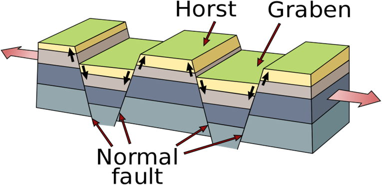
Normal fault
This is a fault caused by forces of tension.
As is shown in the diagram below tensional forces pull the block away causing some parts to sink.
On a plane, when there are a series of normal faults the raised up blocks are known as horsts while the sunken parts/troughs are the graben.
Through time the horsts will remain as block mountains while the troughs are rift valleys.
The grabens are also known as rift valleys with escarpments (fault scarp) being previous fault lines.
The Great East African Rift Valley is one example of a graben.
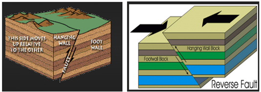
Reverse fault
A reverse fault is formed by forces of compression as shown in the diagram below.
Sometimes two hanging wall blocks can override a footwall block resulting in a valley/graben.
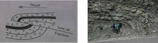
Thrust fault
This is a fault resulting from a progression of a fold until it breaks along a plane (thrust plane).
It has been discussed under folding where it is referred to as an over thrust fold.
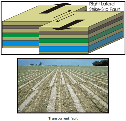
Transcurrent/shear fault
It is also known as transverse or strike fault.
It results from two tectonic forces moving in opposite directions.
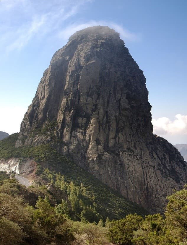
In real life the effects of shear faulting are seen in dislocated lines such as roads, railway lines, ridges like those shown in the picture above and any other linear structures.
This type of faulting is, as earlier on indicated, spectacularly seen in California State of USA.
Other vertical earth movements
These movements are upwards and create heights and depths .Evidence of such movements has been noticed in coastal areas where the beaches have been raised above sea level. In West Africa, countries like Ghana and Sierra Leone have some beaches now lying above sea level.
Such heaving of the earth happens because of both erosional effects and tectonic adjustments.
Vulcanicity
The rising of molten magma within and on to the earth's surface under immense pressure is what is referred to as vulcanicity.
Due to great pressure within the mantle, any fault or line of weakness above magma gives in to molten magma which rises up and flows across or laterally in a violent manner.
The cracks are widened by the magma which consequently creates some vibrations on top observed as minor earthquakes.
The processes of vulcanicity and earthquakes are usually inseparable as in most of the cases they occur simultaneously.
Vulcanicity operates in two forms, intrusive which occurs within the crust and extrusive which happens as magma comes out as lava.
In cases where the crust develops a deep fault right down to the asthenosphere, the magma is violently ejected out to reach the surface as lava which cools and solidifies to form extrusive rock features.
The nature of rocks within the crust also impacts on the success of magma to escape.
In areas with hard resistant rock convection currents may fail to bring deep faults hence resulting in failure of molten magma to reach the surface and as such cause it to solidify underground as intrusive rocks.
Intrusive and extrusive features are discussed in detail hereafter.
Extrusive volcanic landforms
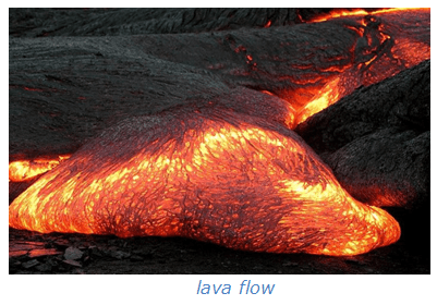
When magma escapes to the surface it is called lava.
Features that are formed by vulcanicity at the surface are called extrusive features.
These features include volcanic cones, lava plateaus and geysers.
The three main types of volcanic features formed on the surface are
Ash and cinder cone
Lava cone
Composite cone
When magma reaches the surface via a vent (hole) it forms a volcano that is a cone shaped mound of solidifying lava.
A fissure (crack) is responsible for lava plain or lava plateau formations.
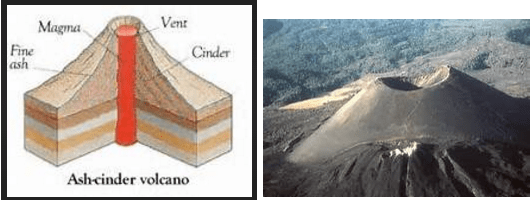
Ash and cinder cone
When lava mixed with cinder is explosively blown out, it will later gather as fragments around the vent. It makes a mound called ash and cinder cone.
The ash and cinder cone is typically gently sloping with concave slope
The smaller lava cones are also found along the flanks of the mound.
Some of them are a result of lava flows which break out, breach the cone or surface out through tunnels.
The angle of the flanks is about 30 degrees to the base like the diagram and picture above.
Lava Cone
There are two types of lava cones the basic or shield, and acid or dome lava cones.
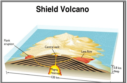
Basic or shield lava cone
This one is formed by basic lava whose resistance to flow (viscosity) is low.
This lava therefore flows for greater distance before it cools and so forms low but broad spreading cones called shields.
Basic lava is dark in colour because it is mostly made up of basaltic rock minerals.
World examples of basic volcanoes include Mauna Loa of Hawaii (USA) and Nyamlagira of DRC in Africa.
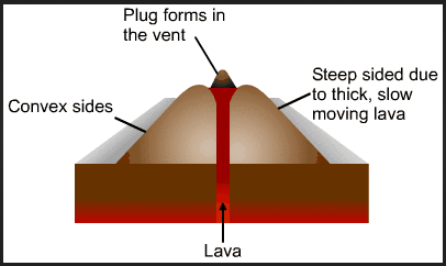
Acidic or Dome volcanoes
The other type lava volcanoes are the acidic type whose lava is highly viscous (resists flowage).
Lava is thick and does not flow for long before cooling.
Volcanoes therefore form high conical domes that have convex slopes.
A volcanic plug
Mount Pelee in the West Indies is a typical acid lava cone.
The top part of the cone is called the spine of viscous lava and lower part 'dressing' the spine is the volcano.
Due to forces of denudation, the lower part of the dome which makes up the volcanic cone may be eroded leaving the plug to stand alone.
Examples of such plug dome formations are the Mount Eden in New Zealand.
Volcanic stages
There are three stages of volcanic activity namely active, dormant and extinct.
For a volcano to be active, this is the stage when its eruptions are highly frequent.
When the eruptions become less frequent, it then becomes dormant (sleeping).
Volcanoes that have not erupted in a long period of time of over 10,000 years are said to be extinct.
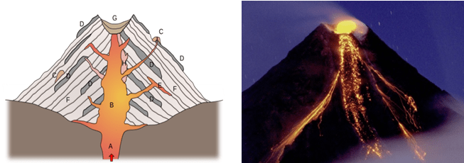
Composite cone
This is a cone made up of alternate layers of ash and lava.
The eruptions are different in manner for each layer of ash and lava.
Initial eruptions are violent and forceful.
The layer of ash is formed in the initial stages of eruption.
It is layered until the violence ceases.
Due to a decline in pressure and violence the lava starts to flow out on top of the previous layer.
The smaller lava cones are also formed on the sides of the parent mound due to lava tunnels branching off the pipe earlier.
These later give rise to dykes which cut diagonally across the bedding planes of the crust.
The smaller mounds on the flanks are conelets.
The structures of Kilimanjaro and Mount Cameroon match the formation of a composite volcano.
Other extrusive volcanic features
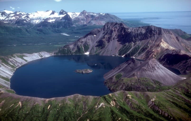
Caldera
When a volcano takes off violently, it blows its top and breaks the rocks and ashes.
It leaves the crater greatly enlarged so as to form a depression called a caldera.
This feature may also be a result of mass subsidence.
This is when the supply of magma depletes, leaving a vacuum below which allows the top weight of mass to crumble down.
So the above processes of explosion and subsidence are two ways in which a caldera is formed.
When the volcano takes a long period of inactivity after the formation of a caldera, eruptions may again take place giving rise to new cones on the caldera floor.
The Krakatoa caldera in the Sunda Strait has conelets within.
Calderas often become sites of lakes, with inner smaller craters forming secondary lakes within a larger lake.
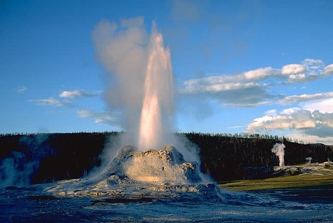
Geysers and hot water springs
In areas where dormant volcanoes exist, emissions of gases and steam may be evidenced.
Underground water is heated when it encounters intrusive magma.
If such water comes out as a spring it will be hot and hence it is called hot spring.
In Zimbabwe we have Nyanyadzi hot springs, Binga hot springs and Mana Pools hot springs.
If water is very hot it may come out as a geyser meaning that it jets out as steam and boiling water.
The geyser has its water ejected in an explosive manner while the hot springs' water may flow quietly.
Geysers often form natural fountains.
Geysers are common in countries like New Zealand, Hawaii and Iceland
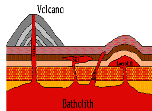
Intrusive volcanic features
These are volcanic features that are formed by magma as it moves upwards towards the surface.
Intrusive volcanic activity produces igneous rock features of different form and structure within the earth's crust.
These are layered or form patterns according to the nature of eruption.
When magma moves inside a crack along the bedding plane, it cools to form a sill (see diagram above).
A sill lies horizontally along the planes but ends where magma cannot extend further.
In a case where the pipe fails to reach out of the crust but spreads along the strata to give a dome shaped block, the feature is called laccolith.
The batholith is a dome shaped block that has pipes radiating from it in different directions.
It is said to be the root of the extrusive volcanic features, namely mountain ranges.
The dyke is the pipe cutting the strata diagonally but fails to reach the surface.
Lopolith is cup shaped igneous block suspended on the volcanic pipe.
Resultant features from intrusive blocks after denudation process
Batholiths only form surface features after being exposed by denudation agents.
Dwalas or dome shaped inselbergs are a result of the exposition of batholiths.
The sills normally give rise to ridge-like escarpments when exposed by erosion.
Others become caps on top of hills which they protect from erosion.
Three Sisters in South Africa are buttes with sill capping.
When sills outcrop across river beds, they form waterfalls.
Dykes maybe vertical or inclined, when eroded some form shallow trenches, while others stand as wall-like ridges.
The dykes may also result in waterfalls when cut across by rivers.
Lopoliths give rise to ruwares or Amadwala.
Earthquakes
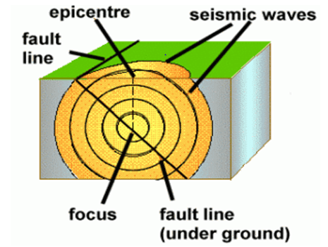
Earthquakes are sudden tremors or vibrations experienced on the earth's surface due to seismic waves released in the interior of the earth.
The vibrations are usually a result of plate movements for example one plate rubbing against the other along a fault line.
Pressure resulting from the movement of molten magma within the crust may also cause the upper crust to vibrate.
As plates fault or shear, seismic waves from within the crust are created to cause movement.
The point where earthquake waves begin or are unleashed from is called the focus or epicenter.
This is usually where a rock fracture or fault occurs.
The magnitude is the energy released by an earthquake that propels seismic waves to move and hit other areas of the crust.
The intensity refers to the destruction or the impact of earthquake.
The position just above the epicenter on the ground level is called epicenter.
This is where the first shock waves hit so as to give rise to an earthquake.
The shock waves are in two types namely body and surface waves.
The force of shock waves is measured by an instrument known as a seismograph and the reading is interpreted on a Richter scale.
A lower reading shows a weak quake and a higher one a strong quake.
Seismic waves are vibrations released by earthquakes that travel through the earth.
The seismograph records a zigzag trace of different amplitudes, from oscillations beneath it.
The Richter scale is a development to the seismograph; it uses the recorded amplitudes from the seismograph so as to give the magnitude of the earthquake.
Types of waves
Body waves travel through the crust and are in two types.
Surface waves travel through the surface rocks and are in two types.
1.primary waves
Push waves
Causes the crustal rock to move back and forth in the direction of wave movement.
1. love waves (L)
Cause the rocks at surface to move from side to side at right angles to the direction of wave movement.
2) Secondary waves
Shake waves
Causes the crustal rock to move from side to side, at right angles to the direction of wave movement.
2) Rayleigh (R)
Causes the surface rocks to have a vertical ripple like movement.
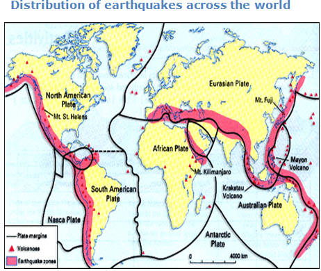
Distribution of earthquakes across the world
Most earthquake zones are located along plate margins where plate tectonic activities occur.
The rising of magma along fault lines creates vibrations due to the convergence and divergence of plates.
In Africa, earthquakes have been witnessed along the Great East African Rift Valley where faulting of the African plate continues to be gradual.
Mount Kilimanjaro exists along this region of volcanoes and earthquakes.
It is the same seismic zone whose effect causes earthquakes along the Zambezi Valley and Eastern Highlands of Zimbabwe.
The Pacific 'Ring of fire' has most of the active volcanoes occurring due to the oceanic plate that is continuously in motion.
Benefits of earthquakes and volcanoes to people
In most cases the occurrences of earthquakes and volcanoes have disastrous consequences to human lives.
However, there are few benefits derived from them.
Benefits of volcanoes
Volcanic soils provide fertile soil for plant growth for example the red soils surrounding the Buchwa Mountain in Zimbabwe; have high deposits of iron which has proved good to irrigation farming.
Minerals can become concentrated in volcanic areas such as the Great Dyke in Zimbabwe.
Examples of minerals found in the Great Dyke are gold, chrome, platinum and iron.
Hot water springs provide healing baths for example in Binga and Mana Pools.
They are also tourist attraction centres for south of Kumasi in Ghana, Lake Toba in Sumatra (Indonesia).
Geothermal (geysers) energy can be obtained from geothermal heat.
Some ridges and islands have been created through vulcanicity and these have been used for human settlement.
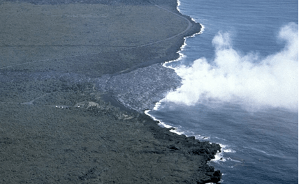
Lava deltas are formed through volcanic activities.
When lava flow reaches the ocean (or any large body of water), contact with water results in both rapid cooling of lava and steam explosions that fragment it.
As the seabed becomes filled, the flow is able to build out.
The spreading of the flow continues as long as lava is supplied.
These types of deltas are a result of low viscosity flows and lava reaches the sea through a system of small lava tubes.
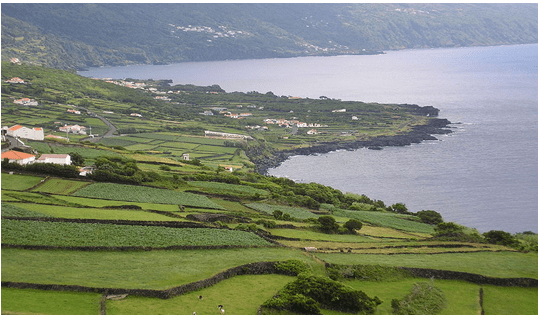
Garachico on Tenerife is a settlement built on a lava delta and has become a tourist attraction centre.
Delta Ponta Dos Biscoitos has turned into a vibrant agricultural zone due to fine fertile lava soils.
Benefits of earthquakes
Earthquakes change the nature of river flow, sometimes changing the directions due to altered terrain gradients. This, however, promotes the birth of new settlements and development.
Earthquakes are sometimes responsible for natural gas leak and oil seepage, which lead to discoveries of new basins.
Earthquakes can also be responsible for lining up minerals.
Vertical rising in or rifting of landscape linked to mineral exposure.
Earthquake and volcanic hazards
Destruction of human lives.
Destruction of property.
Destruction of vegetation after eruption.
Area for infrastructural and agricultural development can be affected by emergence of lava plateaus and ridges.
Acid rain results from gases emitted through the eruption.
Destruction of communication lines through earthquakes.
Respiratory diseases can result due to gases being emitted from the mantle.
Pollution of water bodies.
Newly formed lava deltas are unstable to build on.
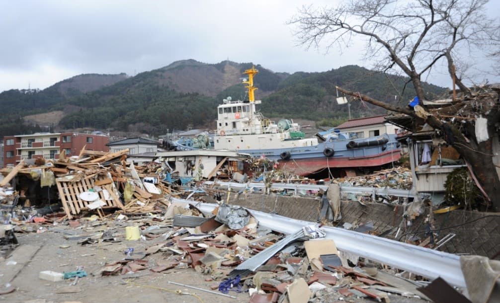
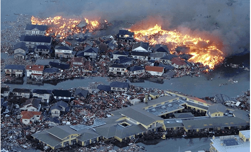
Japanese Tsunami 2011
On March 11, 2011 Japan was hit by an earthquake with a magnitude of 9 on the Richter Scale.
The earthquake further unleashed a savage Tsunami that swept across the north eastern parts, destroying about 15 000 lives with close to 2 500 left missing.
A Tsunami consists of a series of waves, which travel at alarming speeds in the sea or a lake. They cause destruction along the coastal areas through the shoaling effect.
The term Tsunami is a Japanese word that stands for 'harbour wave'.
The effects of the earthquake were felt around the world, with debris continuing to float on North American beaches 4 years later.
The damages translated to an estimated US300 billion (about 25 Trillion yen) according to Japanese government.
The earthquake, furthermore, caused radioactive water to leak at Fukushima Daiichi Nuclear Power Plant.
About 230 000 people who lost their homes, still live in temporary homes four years later.
The damage reached such catastrophic levels owing to few scientists who had predicted the earthquake but with a lower magnitude.
The unexpected earthquake is not the only one to reach such catastrophic levels.
In 2004 Banda Aceh in Sumatra surpassed the level, with a magnitude of 9.1 which killed 230 000 people.
Haiti Earthquake
The other recent earthquake to have hit the world was the 2010 Haiti earthquake which caused 70% of people living on less than one US dollar per day to suffer more.
The 7.0 magnitude earthquake struck near Port Au Prince leaving 3 500 000 people deeply affected.
About 220 000 people were estimated dead leaving 300 000 people injured.
Over 188 383 houses were badly damaged and 105 000 destroyed adding up to 293 383 in all.
The accommodation crisis was estimated at 1.5 million homeless people.
Measures to reduce effect of earthquake and volcanic disasters
Promote research on accurate earthquake and volcano predictions.
Build structures with light and earthquake resistant materials.
Equip regions with rapid disaster response mechanisms.